Hinkson Creek Watershed Restoration Project
The information below is from the Hinkson Creek Watershed Restoration Project Phase II grant, which occurred 6/1/2008 through 10/31/2011.
Members
- Audubon Society
- Boone County Smart Growth Coalition
- Boone County Soil and Water Conservation District Board
- Central Missouri Development Council
- City of Columbia
- Columbia Chamber of Commerce
- Columbia Special Business District
- Farm Bureau
- Greenbelt Land Trust
- Hominy Branch Neighborhood Association
- Missouri Department of Conservation
- Missouri Department of Natural Resources, TMDL Unit
- Missouri Department of Transportation, Central District
- Missouri Stream Teams
- Quarry Heights Neighborhood Association
- Sierra Club
- Sustain Mizzou
- University of Missouri Administration
- University of Missouri Research
Welcome stakeholders!
This page will contain meeting minutes, agendas, and any other documents needed for stakeholder committee business. Documents of public interest, such as a Word version of the watershed management plan, will be placed on the Information Clearinghouse page.
New language in the City Stormwater Manual- Tom Wellman, City of Columbia Stormwater Engineer, asked that the new "channel protection" language that Columbia has recently incorporated into their manual.
2010 Meeting Minutes
- January 19, 2010 - Minutes
- February 9, 2010 - Meeting canceled
- March 2, 2010 - Meeting canceled
- March 23, 2010 - Meeting canceled
- April 20, 2010 - Meeting canceled
- May 25, 2010 - Meeting canceled
2009 Meeting Minutes
- January 13, 2009 - Minutes
- February 3, 2009 - Minutes
- February 24, 2009 - Minutes
- March 17, 2009 - Minutes
- April 7, 2009 - Minutes
- April 28, 2009 - Minutes
- May 19, 2009 - Minutes
- June 2, 2009 - Minutes
- August 4, 2009 - Minutes
- August 25, 2009 - Minutes
- September 15, 2009 - Roundtable discussion. No minutes recorded.
- October 6, 2009 - Minutes
- November 17, 2009 - Minutes
- Decempber 8, 2009 - Meeting canceled
- December 29 - Meeting canceled
Information Clearinghouse
Although the source of pollution in the Hinkson remains a mystery, the Hinkson itself has a fair amount of information written about it. Below are some links that offer information about the Hinkson.
Hinkson Creek Watershed Demographics
- Acres within the watershed: 57,445 acres
- 2000 Census Population: 73,536
- Length in miles: 32.83
- Miles listed as a 303(d) stream: 14
RFP Pre-proposal Meeting Presentation
Information presented at the meeting held on December 11, 2008 can be accessed here. "NOTES" boxes within the presentation summarize the points mentioned in the presentation.
Sampling Data
The Department of Natural Resources (DNR) monitored the water quality of the impaired section of the Hinkson (downstream of I-70) over the last several years. Stormwater outfalls, as well as the Hinkson itself, were tested for a variety of contaminants such as metals, organic compounds, salt, turbidity, and others. Each year, the Hinkson failed to have the diversity of aquatic life needed to be consider a fully functioning stream, though no single contaminant was ever found to be at fault.
Hinkson Creek Watershed Management Plan
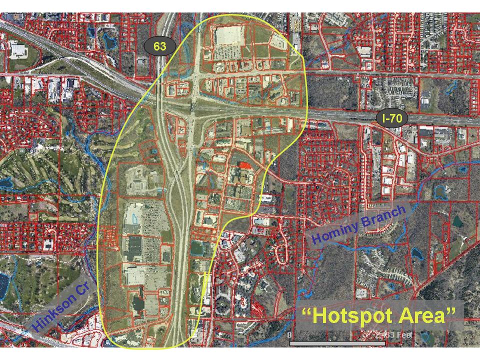
The Hinkson Creek Watershed Restoration Project Phase I grant developed a draft watershed management plan, which served as the base document for the Phase II stakeholder committee to work with. The watershed plan identifies the urbanized hydrology as the main contributor to the degraded condition of Hinkson Creek, identifies a "hotspot" area in which to focus restoration efforts, and makes recommendations for the restoration effort.
Ordinances
Boone County passed a stream buffer ordinance in May of 2009. The ordinance went into effect on June 1, 2009. The ordinance is not retroactive, only new developments and redevelopments are affected. The stream buffer ordinance is very similar to the City of Columbia's stream buffer ordinance.
Boone County passed a stormwater ordinance February 2, 2010. The ordinance went into effect on April 15, 2010. All design plans approved by planning and zoning before April 15, 2010 will not be subject to this ordinance. Plans in the design phase, or not approved by that date will require stormwater controls. The Commission has chosen to delay the implementation of the abeyance (Section 9.3) until the Columbia City Council enacts similar legislation.
A stormwater ordinance and a stream buffer ordinance were both passed by the City of Columbia in 2007. Neither ordinance is retroactive, only new developments and redevelopments are affected. The stream buffer ordinance requires a setback of varying width, dependent upon the size of the stream. The stormwater ordinance requires a level of service approach be taken on applicable developments. Run-off from areas converted to impervious surface are ameliorated by various BMPs that must be installed to detain and treat the stormwater. Visit the City of Columbia's Stormwater Utility page for more information.
Maps
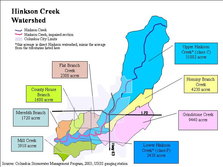
The Hinkson drains roughly 88.5 square miles of land, all in Boone County. Hinkson Creek itself is 26 miles long, originating east of Hallsville and traveling southwest to join Perche Creek in southwest Columbia. Several large tributaries spill into the Hinkson within the Columbia area. Grindstone Creek and Hominy Branch originate from the east, Flat Branch and County House Branch drain the interior of Columbia, and Meredith Branch and Mill Creek drain the western portion of Columbia.
- The Watershed Evaluation and Comparison Tool allows you to view watershed maps, view protected and 303(d) listed lakes and streams, soils, karst features, census data, and much more.
- Our interactive mapping tool allows you to view aerial photos, topographic maps, floodplains, and many more features.
- Our map of the sub watersheds of the Hinkson shows the branches and creeks that make up the Hinkson Creek in it's entirety.
- Our map of the hotspot area of interest outlines the area included in our cost-share program.
Real Time Data
The USGS monitors the flow of the Hinkson just below the Providence Road bridge. The gage was put in place in the late 1960s, but was decommissioned for a decade and was brought online again in 2007. The United States Geological Survey (USGS) has preserved data showing the flow of the Hinkson and an archive of the Hinkson's flow on their USGS National Water Information System Web Interface.
The weather station at MU's Sanborn Field (at Rollins and College Ave) has been recording weather data for many years. This data, or at least the last decade of data, is searchable via the MU website. Precipitation data, both daily and annual accumulation, soil temperature, air temperature, and other parameters, are available. Visit the Missouri Historical Agricultural Weather Database to search the data archives.
Research
Michele Baumer, a graduate student at the University of Missouri conducted a study of attitudes of residents in the watershed about Hinkson Creek and other environmental issues.
Dr. Jason Hubbart, Assistant Professor of Hydrologic Processes and Water Quality at the University of Missouri is investigating the impacts of land use/ cover changes on hydroclimate, water quality, biogeochemistry, and physical-biological interactions in forested, agricultural, and urban ecosystems within the Hinkson Creek Watershed.
Collaborative Adaptive Management (CAM) on Hinkson Creek
Collaborative adaptive management is a science-driven, stakeholder-based process for decision-making while dealing with the scientific unknowns inherent in many physical and biological systems. It uses a continuing process to make changes and then to determine the effect of those changes. View the Department of Natural Resources' fact sheet for more information.
- November 2009 Feasibility Study
- Hinkson Creek Total Maximum Daily Load (TMDL)
- Hinkson Creek TMDL Settlement Agreement